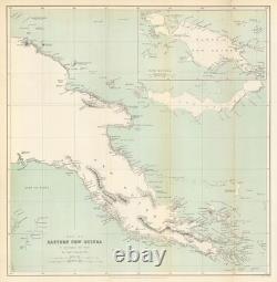
Eastern New Guinea by Capt John Moresby. Papua New Guinea. RGS 1875 old map


Map of Eastern New Guinea. Antique Royal Geographical Society map with related text pages, 1875. Caption below picture:'Map of Eastern New Guinea. By Captain John Moresby, R.
41.5 cm (16.75? Compiled from Royal Navy surveys aboard HMS Basilisk (1873? 74), delineating the south-eastern coastline, reefs, and anchorages later forming British New Guinea. Moresby was the first European to discover the site of Port Moresby. IMAGE SIZE: Approx 42.5 x 41.5cm, 16.75 x 16.25 inches (Large); Please note that this is a folding map.
ARTIST/CARTOGRAPHER/ENGRAVER: Royal Geographical Society / Capt. PROVENANCE: "The Journal of the Royal Geographical Society of London", Volume the Forty-Fifth 1875. London: John Murray, Albemarle Street. TYPE: Antique Royal Geographical Society map with related text pages.
VERSO: There is nothing printed on the reverse side, which is plain. CONDITION: Good; suitable for framing. Virtually all antiquarian maps and prints are subject to some normal aging due to use and time which is not obtrusive unless otherwise stated. AUTHENTICITY: This is an authentic historic print, published at the date stated above.I do not offer reproductions. It is not a modern copy. The term'original' when applied to a print means that it was printed at the first or original date of publication; it does not imply that the item is unique.
Print' means any image created by applying an inked block to paper or card under pressure by any method including wood engraving, steel engraving, copperplate, wood cut and lithography. REMARKS: FRANCE: Gravures et Cartes anciennes.
DEUTSCHLAND: Alte Lankarten und Stadt ansichten. ITALIA: Stampe e Mappe antiche. A: Mapas antiquos y impresiones antiguas.

